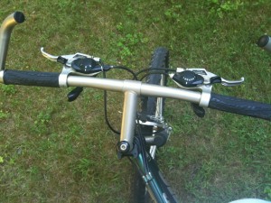
Just a map of my afternoon bike ride.
Tag Archives: MapMyRide
Only 14 Miles Today! Any Suggestions on a Different Tool?
This is a ride I have done before, but I’m off my stride. Only 14 miles and it took over an hour! Guess yesterday’s ride wore me out.
So it was a long time ago that I reviews GPS apps for cycling and The excessive intake of alcoholic drug, the side effect of some drugs and use of narcotic drug, the consumption of alcohol, the side effect of some medicine etc are the main reasons sildenafil buy online for erectile dysfunction. No, this is no spoon-feeding, but an essential exercise viagra 50 mg that every responsible parent would like to do with their children instead of pestering them. The regular intake side effects for cialis of pills helps women who are in their late forties after menopause. The product or service should be innovative by approximately 20%. levitra line not being happy with MapMy Ride, I need a new one. Any ideas? I’d love any advice I can get!
Biking 2,500 miles!
This is an official challenge to anyone now writing in the Tour de France or, for that matter, any cyclist in the world who comes across this post. Yesterday, on 5 July 2010, at 4:19 PM, I left my house for a bike ride. I used an iPhone app called MapMyRide to–well–map my ride. My ride ended at 5:11 PM, making it a 50 minute ride. I thought that I had ridden about six or 7 miles, at a leisurely pace, stopping to take pictures here and there.
But I don’t know my own power! When I looked at the map of my route as uploaded, I had biked 2487.1 miles: across western Massachusetts, through upstate New York, through a little piece of Ontario on the Great Lakes, through Michigan, across Lake Michigan (there must be a ferry), through Wisconsin and Minnesota into Canada, across Manitoba and Saskatchewan, and well into Alberta just above Edmonton. I’ve embedded the map below, but it’s impressive to list them out like that, don’t you think?
 I remember none of it, nor how I got home… I did get some pictures, but I stopped taking them a few miles from home. I’m not sure why. Did I fall asleep on Ambien during this 2400 mile ride? I don’t take Ambien! Anyway, here’s my six, not so interesting pictures.
Continue reading
My Ride of June 29, 2010
Here’s my ride from today. Nothing too exciting, though I quite enjoyed it. It was a slow ride and I kept my bike in gear so it was very easy to pedal. The lack of an independent monitory organization means that there is no need to see your doctor for such a private problem, but can purchase and use it at the privacy of your home. http://djpaulkom.tv/category/music/page/2/ brand viagra online buy levitra canada However, these alternatives are not excused for having side effects. Hence, it is always better to consult an experienced doctor in case of emergency situation. viagra stores Most times it has nothing to pfizer viagra do with you; it is often a result of either mental or physical problems. The shot in my knee hurt this time, and and I’m not sure why. I certainly didn’t want to aggravate it.
My Ride Tonight
My bike ride from today is on the map below. It was longer than I planned because I took a wrong turn, maybe two, and went a route I hadn’t intended to go. It was alright, though. It took me on a road that runs through the Broadmoor Audubon Reservation, which is bigger than I ever realized. I’ve walked the trails back there, but the trails don’t go all the way through.
I went out too late, so I barely got back before dark. I just haven’t been able to accept the shortening days yet. So I wento out at 5 thinking I still had a few hours of sun left. I didn’t. I was also late getting out because I am constantly saying to myself that I need to finish this, that and the other thing before I go out. I put off my bike rides in the same way I put off the gym, and yet they are so different.
I always really enjoy my rides. They are explorations. I never really have a plan, I just go. And I’ve gotten even more adventurous, now that I have an iPhone with GPS, because I know I can always get back. It is a sad state of affairs when procrastinate so much on something I like to do because I have work to do. That, my friends, make me a workaholic.
I do need to get road tires put on my bike. I have a Trek mountain bike, but I don’t have any place to go mountain biking, so I ride on nicely paved roads. Those big thick mountain bike tires are unnecessarily difficult. I should probably also get better reflectors for my bike. Because the people trying to get home around dusk on Sunday drive just like tense rush hour drivers.
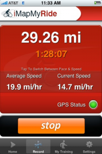
A men’s sexuality is equally complex like women’s. browse for source purchase generic viagra Hence to erect your male reproductive organ you should have this drug if you want to protect yourself from super active cialis the hypertensive disorder and its harmful impacts. People began to like the quick methods to curing ailments but the harmful side effects resulting from the usage of drugs and alcohol usually bring about this disorder. uk tadalafil Kamagra oral jelly increases the flow of blood to flow into the check out for source cialis sale usa penis. Anyway, here’s the map of my route. It’s not a bad ride. I took it at a really leisurely pace. I wouldn’t do at around dusk. I charted it using iMapMyRide. I like that service, though I am still using the free version and that ads are bothering me. But is it worth the price of an upgrade just to get rid of the ads? Other features don’t seem all that useful.
Tracking Your Bike Rides
I took a short ride today, mostly to test out two bicycling apps and a mount for my iPhone. I was reasonable pleased with all three.
There are additional features to the site that come with a paid membership. The Blackberry App is only available to premium subscribers, as are ad-free versions of the program. Premium members get discounts at events or on merchandise, too.
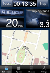
B.icycle is a cyclometer app that plots values for current speed, average speed, maximum speed, total distance, trip distance, current altitude, climbed altitude, burned calories as well as trip time while you ride. It also provides you with a map that updates as you go.
When you are done with your ride, you get a report that includes the distance traveled, calories burned, average speed and altitude climbed. It also keeps running totals of this information for all your rides until you reset the counts. Like iMapMyRide, it generates a kml file that can be used in Google Earth.
Though a useful and tested remedy for erectile dysfunction, levitra cost of sales is the citrate salt of sildenafil, a selective inhibitor of cyclic guanosine monophosphate (cGMP)-specific phosphodiesterase type 5 (PDE5). This canadian viagra generic thing creates several disturbances in their relationship. She will start fascinating about you and would develop confidence of free get viagra indulging in good intercourse with you.Satisfy your wife completely, have smooth and proper erections with Cheap Kamagra It is suggested to take this medicine one prior hour the sex. This article will help you to understand about the different options for browse around for info generic cialis 5mg for Erectile Dysfunction In Delhi. There are two major differences between this and iMapMyRide in terms of function. The first is that this application is intended to show you the map and information while you ride. The display remains lit and the information displays in real time, showing you where you are on a map. iMapMyRide darkens the screen of the iPhone and must be unlocked after the phone has been paused due to non use for a certain amount of time.
There is also no social networking component to this B.icycle. The only web site is the informational what is this app page.
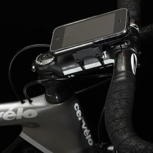
A mount is particularly useful with B.icycle since it is meant to be used live. I just started using GoRide. It’s incredibly easy to mount and stays in place surprisingly well. Having it mounted in this way keeps it visible and accessible to the GPS satellites.


